NukesYou Will Survive DoomsdayBy Bruce BeachTable of Contents
Useful Figures and Tables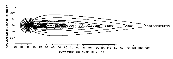
This was the fallout pattern 36 hours after a single 15-megaton thermonuclear device (the Bravo shot of Operation Castle at Bikini Atoll - March 1, 1954) was detonated. The eventual extension of the fallout was more than 20 miles upwind and over 320 miles downwind. The width in cross section was variable, the maximum being over 60 miles. This means there was substantial fallout contamination over an area of more than 7000 square miles. It is important to note that persons anywhere downwind would not have had to travel more than 40 miles in a direction crosswind to be perfectly safe. Secondly, assuming upperwinds of 150 miles per hour and descent times of 30 minutes, persons 150 to 200 miles away would have over an hour in which to either evacuate the area or to take shelter. As noted from the chart on the effects of radiation on humans, the 300 roentgens per hour would cause serious illness with some fatalities after an exposure of 1 hour and exposure of 2 hours would certainly cause a hard death occurring in hours to days. 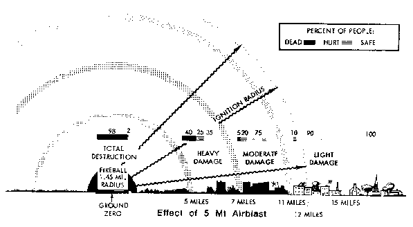
This picture shows the effect of a 5-megaton airblast. While much larger weapons have been developed experimentally their use is unlikely. For one thing they are to hard to deliver and, more importantly, with a 20-megaton weapon we do only about one third the damage that will be caused by 4 five-megaton weapons. 5 to 8 megatons will probably be the average size of the strategic weapons. They will probably be detonated at some altitude around 2000 feet for maximum effect. At 15 to 18 miles on a clear day exposed people will be blistered, and from 18 to 23 miles they will be sunburned. 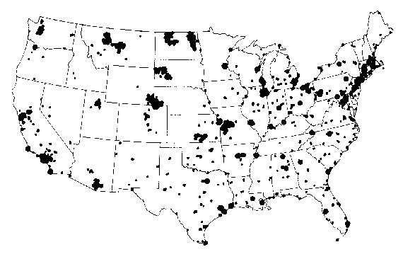
This map shows the principal targets in the US. Major airports, military installations, and railway passes would be targets in Canada. The number two target in North America is North Bay, Ontario. In an all out nuclear exchange (WW III), with a multiplicity of devices being detonated over a relative short period of time (three days to two weeks is a common estimate), there would most likely be wide spread areas with general radiation levels (in the 5 to 20 roentgen per hour range) over 1000 miles down wind from the blast sites, two to three days after zero hour. 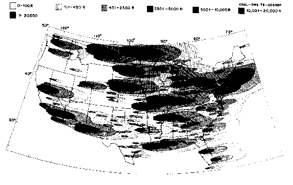
This map indicates the amount of radiation that a person would receive in various areas by remaining in the open for 14 days following the bombing of targets indicated in the map above. It is important to note from the map that even if Canada were not bombed that Ontario would receive 101 to 450 roentgens from the MinuteMan sites in Montana and the Dakotas. 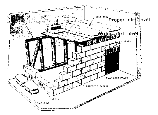
The effect of a mere 10 roentgens per hour (arriving two or three days after a detonation and thus having already lost much of its rapid decay) would cause serious illness after one day's exposure, and (even with continued decay) would cause certain death within a couple of weeks. However, almost any expedient shelter would greatly minimize the effects. The basement shelter shown here could mean the difference between life and death. As much care as possible should be taken to make sure the shelter roof is below outside ground level. Otherwise, radiation will come in at an angle through the narrow basement wall, as demonstrated. Seven/Ten Rule
         1 hour ------------------ 1000  roentgens/hour
         7 hours -----------------  100  roentgens/hour
        49 hours (2 days) --------   10  roentgens/hour
         2 weeks -----------------    1  roentgens/hour
        14 weeks -----------------  0.1  roentgens/hour
        98 weeks (2 1/2 years) ---  0.01 roentgens/hour
This chart indicates that if one started off with one thousand roentgens of radiation per hour at zero plus 1 hour, that it would take 2 weeks for the radiation to get down to 1 roentgen per hour. Since death would be almost certain after exposure for even 1/2 hr (see accompanying chart) it is apparent that shelter would be necessary. The important thing to remember about the seven/ten rule is that it is only theoretical, and that actual decay may follow a different slope. Secondly, in order to use it. one must know the exact time of detonation for the weapon causing the fallout. And thirdly, it is only applicable for calculating the fallout from one weapon, and not for multiple sources. [Author's update note: The above is a map of the underground shelter actually built 90 miles northwest of Toronto. Anyone interested in joining the survival community where it is located should email the author for photos of the existing shelter. ]. |
|